File:RelationsForConnectingE-Roads02.jpg
From OpenStreetMap Wiki
Jump to navigation
Jump to search
RelationsForConnectingE-Roads02.jpg (432 × 353 pixels, file size: 14 KB, MIME type: image/jpeg)
This file and its description are from Wikimedia Commons.
Summary
| DescriptionRelationsForConnectingE-Roads02.jpg |
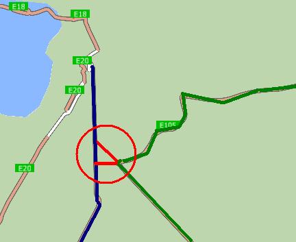
Русский: Отношения для соединения маршрутов. Синяя линия - маршрут E 95, зелёная линия - маршрут E 105, красная линия - соединительное отношение. Карта для навигационной программы CityGuide сгенерирована для сайта http://peirce.gis-lab.info на основе данных OSM.
English: Relations for connecting routes. Blue line - route E 95, green line - route E 105, red line - connecting relation. The map for CityGuide software was made for website http://peirce.gis-lab.info, it is based on OSM data. |
| Date | |
| Source | OpenStreetMap and http://peirce.gis-lab.info |
| Author | contributors of OpenStreetMap and http://peirce.gis-lab.info |
| Camera location | 59° 48′ 26″ N, 30° 22′ 25″ E | View this and other nearby images on: OpenStreetMap |
|---|
Licensing
| DescriptionRelationsForConnectingE-Roads02.jpg |
This map was created from OpenStreetMap project data, collected by the community. This map may be incomplete, and may contain errors. Don't rely solely on it for navigation. |
|||
| Date | (see file history) | |||
| Source | openstreetmap.org | |||
| Creator |
OpenStreetMap contributors |
|||
| Permission (Reusing this file) |
OpenStreetMap data is available under the Open Database License (details). Map tiles are licensed under the Creative Commons Attribution-ShareAlike 2.0 license (CC-BY-SA 2.0).
This file is licensed under the Creative Commons Attribution-Share Alike 2.0 Generic license.
|
|||
| Georeferencing | Georeference the map in Wikimaps Warper If inappropriate please set warp_status = skip to hide. |
Captions
Add a one-line explanation of what this file represents
Items portrayed in this file
depicts
copyright status<\/a>"}},"text\/plain":{"en":{"":"copyright status"}}},"{\"value\":{\"entity-type\":\"item\",\"numeric-id\":50423863,\"id\":\"Q50423863\"},\"type\":\"wikibase-entityid\"}":{"text\/html":{"en":{"P6216":"copyrighted<\/a>"}},"text\/plain":{"en":{"P6216":"copyrighted"}}}}" class="wbmi-entityview-statementsGroup wbmi-entityview-statementsGroup-P6216 oo-ui-layout oo-ui-panelLayout oo-ui-panelLayout-framed">
copyright license<\/a>"}},"text\/plain":{"en":{"":"copyright license"}}},"{\"value\":{\"entity-type\":\"item\",\"numeric-id\":19068220,\"id\":\"Q19068220\"},\"type\":\"wikibase-entityid\"}":{"text\/html":{"en":{"P275":"Creative Commons Attribution-ShareAlike 2.0 Generic<\/a>"}},"text\/plain":{"en":{"P275":"Creative Commons Attribution-ShareAlike 2.0 Generic"}}}}" class="wbmi-entityview-statementsGroup wbmi-entityview-statementsGroup-P275 oo-ui-layout oo-ui-panelLayout oo-ui-panelLayout-framed">
inception<\/a>"}},"text\/plain":{"en":{"":"inception"}}},"{\"value\":{\"time\":\"+2013-03-13T00:00:00Z\",\"timezone\":0,\"before\":0,\"after\":0,\"precision\":11,\"calendarmodel\":\"http:\\\/\\\/www.wikidata.org\\\/entity\\\/Q1985727\"},\"type\":\"time\"}":{"text\/html":{"en":{"P571":"13 March 2013"}},"text\/plain":{"en":{"P571":"13 March 2013"}}}}" class="wbmi-entityview-statementsGroup wbmi-entityview-statementsGroup-P571 oo-ui-layout oo-ui-panelLayout oo-ui-panelLayout-framed">
13 March 2013
media type<\/a>"}},"text\/plain":{"en":{"":"media type"}}},"{\"value\":\"image\\\/jpeg\",\"type\":\"string\"}":{"text\/html":{"en":{"P1163":"image\/jpeg"}},"text\/plain":{"en":{"P1163":"image\/jpeg"}}}}" class="wbmi-entityview-statementsGroup wbmi-entityview-statementsGroup-P1163 oo-ui-layout oo-ui-panelLayout oo-ui-panelLayout-framed">
image/jpeg
checksum<\/a>"}},"text\/plain":{"en":{"":"checksum"}}},"{\"value\":\"f64003948b6bc71638c935c148e5e608369548fd\",\"type\":\"string\"}":{"text\/html":{"en":{"P4092":"f64003948b6bc71638c935c148e5e608369548fd"}},"text\/plain":{"en":{"P4092":"f64003948b6bc71638c935c148e5e608369548fd"}}},"{\"value\":{\"entity-type\":\"property\",\"numeric-id\":459,\"id\":\"P459\"},\"type\":\"wikibase-entityid\"}":{"text\/html":{"en":{"":"determination method or standard<\/a>"}},"text\/plain":{"en":{"":"determination method or standard"}}},"{\"value\":{\"entity-type\":\"item\",\"numeric-id\":13414952,\"id\":\"Q13414952\"},\"type\":\"wikibase-entityid\"}":{"text\/html":{"en":{"P459":"SHA-1<\/a>"}},"text\/plain":{"en":{"P459":"SHA-1"}}}}" class="wbmi-entityview-statementsGroup wbmi-entityview-statementsGroup-P4092 oo-ui-layout oo-ui-panelLayout oo-ui-panelLayout-framed">
f64003948b6bc71638c935c148e5e608369548fd
data size<\/a>"}},"text\/plain":{"en":{"":"data size"}}},"{\"value\":{\"amount\":\"+14024\",\"unit\":\"http:\\\/\\\/www.wikidata.org\\\/entity\\\/Q8799\"},\"type\":\"quantity\"}":{"text\/html":{"en":{"P3575":"14,024 byte<\/span>"}},"text\/plain":{"en":{"P3575":"14,024 byte"}}}}" class="wbmi-entityview-statementsGroup wbmi-entityview-statementsGroup-P3575 oo-ui-layout oo-ui-panelLayout oo-ui-panelLayout-framed">
14,024 byte
height<\/a>"}},"text\/plain":{"en":{"":"height"}}},"{\"value\":{\"amount\":\"+353\",\"unit\":\"http:\\\/\\\/www.wikidata.org\\\/entity\\\/Q355198\"},\"type\":\"quantity\"}":{"text\/html":{"en":{"P2048":"353 pixel<\/span>"}},"text\/plain":{"en":{"P2048":"353 pixel"}}}}" class="wbmi-entityview-statementsGroup wbmi-entityview-statementsGroup-P2048 oo-ui-layout oo-ui-panelLayout oo-ui-panelLayout-framed">
353 pixel
width<\/a>"}},"text\/plain":{"en":{"":"width"}}},"{\"value\":{\"amount\":\"+432\",\"unit\":\"http:\\\/\\\/www.wikidata.org\\\/entity\\\/Q355198\"},\"type\":\"quantity\"}":{"text\/html":{"en":{"P2049":"432 pixel<\/span>"}},"text\/plain":{"en":{"P2049":"432 pixel"}}}}" class="wbmi-entityview-statementsGroup wbmi-entityview-statementsGroup-P2049 oo-ui-layout oo-ui-panelLayout oo-ui-panelLayout-framed">
432 pixel
coordinates of the point of view<\/a>"}},"text\/plain":{"en":{"":"coordinates of the point of view"}}},"{\"value\":{\"latitude\":59.807222,\"longitude\":30.373611,\"altitude\":null,\"precision\":1.0e-6,\"globe\":\"http:\\\/\\\/www.wikidata.org\\\/entity\\\/Q2\"},\"type\":\"globecoordinate\"}":{"text\/html":{"en":{"P1259":"59\u00b048'25.999"N, 30\u00b022'25.000"E"}},"text\/plain":{"en":{"P1259":"59\u00b048'25.999\"N, 30\u00b022'25.000\"E"}}}}" class="wbmi-entityview-statementsGroup wbmi-entityview-statementsGroup-P1259 oo-ui-layout oo-ui-panelLayout oo-ui-panelLayout-framed">
59°48'25.999"N, 30°22'25.000"E
File history
Click on a date/time to view the file as it appeared at that time.
| Date/Time | Thumbnail | Dimensions | User | Comment | |
|---|---|---|---|---|---|
| current | 20:24, 13 March 2013 |  | 432 × 353 (14 KB) | wikimediacommons>Dinamik | == {{int:filedesc}} == {{Information |Description= {{ru|Отношения для соединения маршрутов. Синяя линия - маршрут E 95, зелёная линия - маршрут E 105, красная линия - сое... |
File usage
The following page uses this file:

